Tuesday, May 31, 2011

The Badlands – Day 2

I woke this morning, looked out the window and there was sunshine and clear skies. I dressed, and went down for breakfast. After breakfast I returned to my room and checked the weather. There was to be lots of sunshine, temps rising to near 70 and lots of Wind. I left the hotel a little after 8 am and drove to the park, reversing the route I took yesterday. At the Pinnacles entrance to the park I inquired about the Sage Creek Rim Road and was told is was open today.

I headed down the Badlands Loop Drive to Sage Creek and turned down that road. It was a maintained gravel road and was dry on the high spots, but still wet on the edges, but passable. I drove down Sage Creek approximately 5 miles, stopping at a couple of overlooks on the route. I ended at Roberts Prairie Dog Town and then returned to the Badlands Loop.

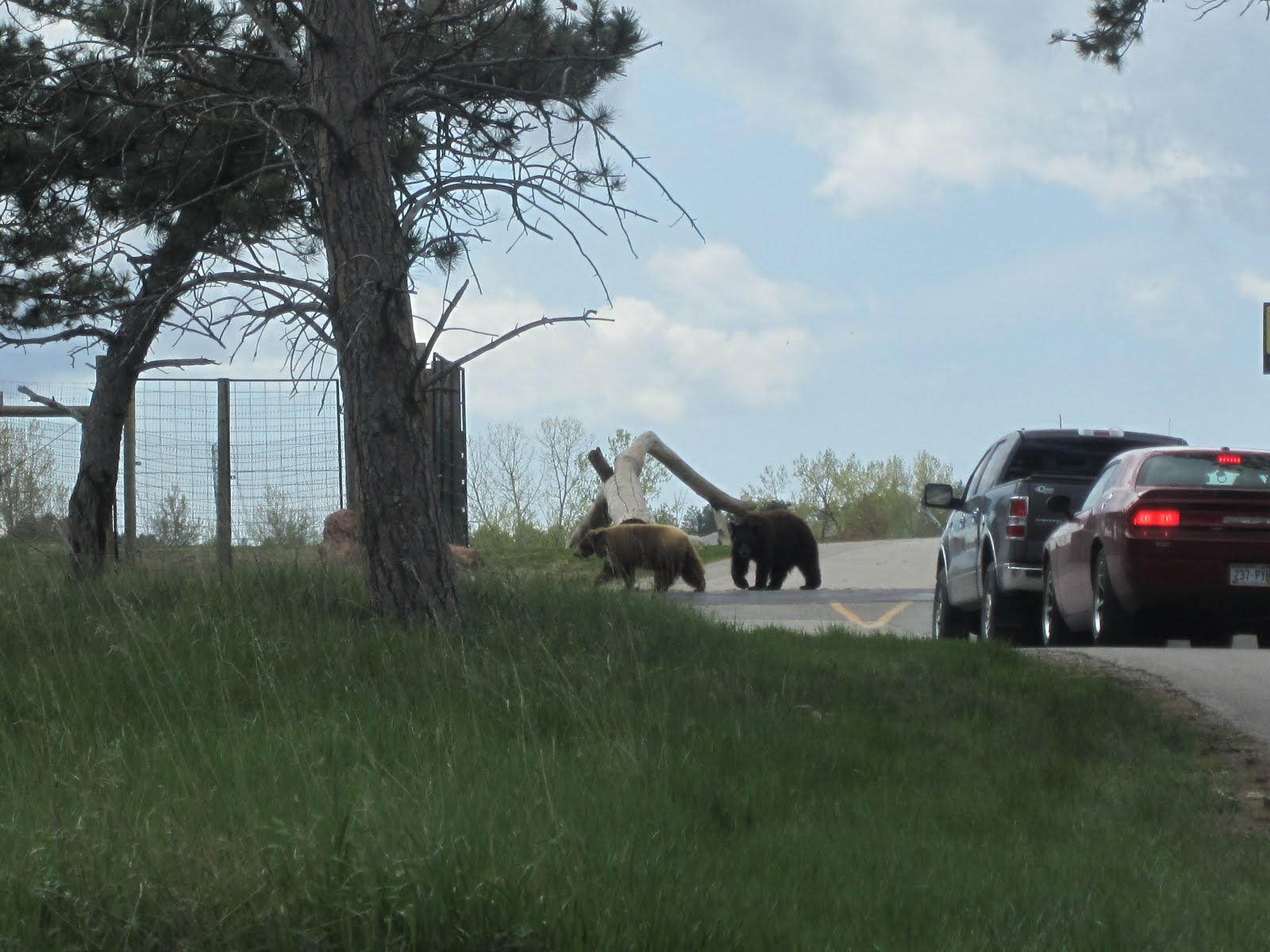
I drove toward the Visitor Center, 20 miles away to check on the condition of the hiking trails today. Along the way I stopped at some of the scenic overlooks I had visited yesterday, but today there was sunshine to help highlight the colors on the formations better than the overcast yesterday.


I arrived at the Visitor Center around 10:30 am and checked on the condition of the trails which were drying out but were still uncertain how passable they would be. I had planned to hike the Medicine Trail loop which was 4 miles round trip and headed up the road to that trailhead. I arrived a few minutes later, put on my hiking boots, strapped on my backpack and started out for the trailhead. About 200 feet down the trail I ran into standing water on the trail for long stretches for as far as I could see. Not knowing how it might be along the trail, given the starting conditions. So, I turned around and went back to the car, stowed my back pack and drove back to the main road.

I drove on down to the Notch Trail and Window Trail. Notch trail is a 1.5 mile round trip hike up the formations to an overlook of the White River Valley. It was a moderate to strenuous hike that required climbing a log ladder about 50 feet high. I put on my back pack and headed off. It took a little over 30 minutes to reach the summit so to speak. There were several places where there were “notches” in the formation from which you could see the valley below. After surveying the scenery, taking some photos and having a short rest and some water, I headed back down.

I returned to the parking area, stowed my back pack and started off on the Window Trail. It was a ¼ mile, boardwalk trail that ended at a natural “window” with a view of the badly eroded canyon. I returned to the car and had a trail mix bar and the rest of my bottle of water.

From there I drove on up to the Big Badlands Overlook and tool some more photos now that I had a day with sunshine. Since it is at one of the higher elevations, the wind was blowing much stronger than at some of the other overlooks.

After that I drove back toward the Visitor Center and Cedar Pass to take the road out of the park on the south entrance and drive to the Wounded Knee Massacre site about 70 miles away. I arrived around 3 pm and fortunately there was a flagman at a road construction site at the town of Wounded Knee. He asked if I was planning to turn west and when I told him why I was there, he directed me to a dirt road about 100 yards away that led to the site. It was a good thing, since there were no markers or signs indicating where it was.

I drove up the dirt road several hundred yards to the site, which is a cemetery where the massacre took place. I got out and began walking into the cemetery. A few minutes later and young Native American girl came up and asked if I was visiting the site and had some dream catchers she was selling, She was joined a few minutes later with other residents and items they had to sell or requesting a donation, etc. I spoke with some of them and heard about the details of the massacre, where the Calvary was positioned, where Big Foot was and his warriors, etc. It was interesting to hear them relate the incidents. After visiting the site for a while I got back in my car to drive to the hotel, which would take me back to the park and then out the north entrance to I-90.

I returned to the hotel around 5 pm. After that I unloaded some items from the car and rearranged things in the back seat to get ready for my drive tomorrow. I went to my room, cleaned up a bit and headed down the street to the Red Rock Restaurant for dinner. For dinner I had a Buffalo Burger. It was pretty good, but slightly different than a beef burger. The meat is not as fatty as say ground chuck, denser in texture and not as flavorful in my opinion, probably because of the lower fat content. After dinner I went and gassed up the car for the trip tomorrow and returned t the hotel.

Tomorrow I drive to Sioux Falls, SD to stay over for the night as the first leg of my trek homeward. On the way I plan to visit the Minute Man Missile Historic Site which is at the same exit for the park north entrance. I am glad I had another day at The Badlands and that the sun was in ample supply today compared to yesterday. It was windy though with gusts over 30 mph. Over the past two days I met people from Michigan, Illinois, Wisconsin, Ontario and Germany. Over the course of the past 5 weeks, I met more people from Wisconsin than any other location. Makes me wonder if anyone is left in Wisconsin or are they all visiting national parks in the west.


 Here are some photos from yesterday. I am having trouble downloading today’s photos and will post them when I can.


See you down the road!

Monday, May 30, 2011

Badlands Day 1

Note: I cannot download pictures from my camera because there are too many images on the memory card. I guess at this point I will have to wait until I get home to download the rest of the pictures taken on the trip since yesterday, because I don’t have a card reader that I can use to transfer the images. Bummer!

This morning when I got up it was overcast, cool and misting outside. I dressed, had breakfast and headed out around 8:30 am. I drove over to the National Grasslands Visitor Center here in Wall, SD to see what might be able to be seen at the Buffalo Gap National Grasslands which surround much of The Badlands National Park. After that I headed down I-90 a little over 20 miles to enter the park on the Northeast Entrance since the Visitor Center was on that end of the park. My plan was to work my way back to Wall on the Badlands Loop drive in the park. On the way I stopped at the Historic Prairie Home just outside the park. I then headed on down the road to the park entrance. By this time the rain and misting had stopped and the sun was trying to make an appearance occasionally.

Once inside the park I made my way to the Visitor Center, 5 miles away on the park Badlands Loop Drive, stopping at several overlooks along the way. I arrived at the Visitor Center around 10:45 am. At the Visitor Center I got my last stamp for my passport for this road trip adventure. I then talked with a Park Ranger about conditions in the park. All of the trails were wet and muddy from the rains the past two days, so hiking was not in the cards for today. The trails usually dry out pretty quickly and tomorrow the forecast is for sun, temp near 70 with gusty winds, so the trails might dry out for some hiking.

I went back to car and continued on the loop drive that would take me back to Wall about 30 miles away. Along the way I stopped at the various overlooks and trail heads, checking the trail conditions (still muddy). At the Big Foot Pass overlook I stopped and had my lunch/snack consisting of t a couple of trail mix energy bars and some water. I continued on after that along the loop drive, stopping at the overlooks. The weather varied from overcast to partly sunny most of the day, but by about 1:30 pm the sun was winning the battle with the clouds and temp was approaching 60F.

I arrived back in Wall around 2:45 pm and decided to visit the Wounded Knee museum. I returned to the hotel around 3:30 pm. Shortly after I arrived at the hotel, the skies which had been sunny began to darken again. I checked the weather and line of showers was moving up from the southwest.

A little after 4 pm I drove downtown (4 blocks away) to the Badlands Bar and ordered pizza for dinner. It was pretty good. While eating, the rain finally made its reappearance around 4:30 pm. After dinner I walked around the downtown area (one block long) browsing in the various shops, including Wall Drug, which takes up about half of one side of the street.

I returned to my hotel room a little after 5 pm and started downloading my pictures, or least that’s what I had hoped to do until I kept getting a communication error. Finally, after re-installing the camera software, I checked the camera user guide and discovered the problem is having too many images on the memory card to download to my computer, So, I guess this means I won’t be able to post any more pictures on my blog until I get home. I will work on it some tonight as I can delete some pictures from the memory card to possibly get to a point where I can download them to my computer.

Hopefully tomorrow will turn out as forecast and I can possibly hike some of the trails. If that doesn’t pan out I may drive down to the Wounded Knee Massacre site.

See you down the road!

Sunday, May 29, 2011

A good Day for Spelunking


I woke this morning a little before 7 am, looked out the window and it was dreary and raining. I checked the weather and rain was forecast all day with temps rising from the mid 30s to mid 40s. I showered, dressed and went down for breakfast. After breakfast I got all my things together and checked out of the hotel. I then headed toward Wind Cave National Park about 7:45 am to arrive around 8:15 am, which I did. Once I arrived I went to the Visitor Center and bought tickets for the Natural Entrance tour at 8:40 am and the Fairground tour at 11 am.

I milled around the center looking at the exhibits until it was time to go over the gathering area for the tour. The Natural Entrance tour enters the cave adjacent to the original opening to the cave which is where it gets it name from the sound the wind makes as it enters or exits a small 15 inch opening to the cave. The tour lasted a little over an hour and I returned to the Visitor Center to await the second tour. I went and got a snack and then went and viewed the park video. Afterwards I made my way to the elevator building where the Fairground tour started from. This tour explored the middle and upper levels of the cave and took almost two hours.

Wind Cave has three major formations throughout the cave, Boxwork, Popcorn and Frostwork. Boxwork was first discovered in Wind Cave and the cave accounts for 95% of the known Boxwork. Popcorn and Frostwork are the same calcite crystals but form differently depending on the evaporation rate of the wind in the cave. Popcorn looks like it sound and Frostwork forms spiky crystals due to faster evaporation of water in the formations.
Original Wind Cave Entrance where it was first explored


Boxwork Formations


Popcorn Formations


Frostwork Formations

After the second tour I went to the car to drive on to Wall, SD on the north side of The Badlands National Park, leaving around 1 pm. I asked Samantha to navigate us to Wall and she had me turn south out of the park instead of north. Looking at my map, I had an idea of where she was leading me. However, when she wanted me to turn on a country road that cut over to another highway which is where I needed to go, the road was a sandy, gravel road and I wasn’t going 8+ miles on it given the weather conditions. So, I asked her to take us through Hot Springs a few miles further down the highway since there was an intersection with the highway I needed to get to there. In Hot Springs she directed me down a couple of side streets, assuming it was a short cut to the route I needed. However, one of the streets she wanted be to turn on had no street sign and after trying to make adjustments to her “Recalculating” directions, wound up in a dead end. So I back tracked back to the original highway and made it to my route by my maps. After that she navigated me to Wall, SD just fine. The trip was rainy with temps in the mid 40s most of the way. About 30 miles from Wall the rain all but stopped and I made to Wall around 3 pm.


Rainy Drive to Wall, SD

Wall, SD is known as the home of the original Wall Drugstore. Along the highway were numerous signs touting the drugstore and encouraging travelers to visit it and the complex around it which included a Jackalope and animated T-Rex, restaurant, mining company, emporium, art gallery, etc. After I checked in at the Super 8 and relaxed a while, I headed over to the Wall Drugstore which was several blocks away. I walked around the complex for a little while and around 4:30 pm went to the Wall Café for an early dinner since I hadn’t had any lunch.
After dinner I went and gassed up the car for tomorrow’s excursions into The Badlands.


Signs for Wall Drug on the way to Wall, SD

Wall Drug Complex Downtown Wall


Some of the venues in the Wall Drug Complex


She doesn’t say much. I wonder if she can navigate like Samantha?

The forecast for tomorrow is for cool temps (50s) and 60% chance of showers/storms. Maybe by the afternoon it will start clearing since the forecast for Tuesday is sunshine and temps around 70. We’ll see how it goes. Hopefully I can do some hiking on Tuesday if the weather clears as forecast.

See you down the road!

Saturday, May 28, 2011

Mt. Rushmore or less


I got up this morning around 7 am, showered, dressed and went down the hall for breakfast consisting of an English muffing, pastry and coffee. I returned to my room and finished getting ready and headed out around 8:30 am. I headed north out of Custer toward the Crazy Horse Memorial, just a few miles up the road, arriving there around 8:45 am. I decided to go on in and tour the site since it was only $10. I also took the $4 bus tour to the base of the monument. They are working on the horse and have 7 of 10 tiers blasted away. The remaining three will take another 10 years before they can start sculpting the horse. At that rate it may not be finished until after 2100 AD (or BCE for those politically correct).

 Bronze Sculpture with the monument in the background
 Crazy Horse as of today with the outline of the horse’s head traced in white
 The scaffolding on top will be replaced by a single feather sculpture
 Mock up Sculpture
An Indian in the Indian Exhibit

I left Crazy Horse around 10 am and drove to the Mt. Rushmore memorial, arriving there around 10:45 am. I parked the care and walked to the entrance. This being Memorial Weekend there were a lot of people visiting today. I walked through the Hall of Flags, representing each state and to the Grand View Terrace for a closer look at the monument and took some more pictures. On the way the Friends of the Monument were having a souvenir sale with everything $5, s I bought a T-shirt.

 On my way in

Hall of Flags


What a view!
 I then took a walking tour around the Presidential Trail loop at the base of the mountain, returning to the Terrace View lower level where the Visitor Center was located. I went in and toured the exhibit and found where I could stamp my passport. I walked back up to the Grand View Terrace and started making my way out. I stopped at the Hall of Flags and found Texas on the engraved granite columns. It was on the outside of one of the columns, where it was not visible walking down between the columns to the Terrace. Just as well because everybody would want to stop there and it would cause a log-jam of people on crowded days.

 Views from the Presidential Trail


Texas inscription and flag at the Hall of Flags


As I walked back out I saw the Carver Café and it being around lunch time, decided to go there for lunch, where I had a hamburger, fries and a Coke. The Carver Café, though I’m sure it has been remodeled since, is where that famous scene from “North by Northwest” was filmed, 50 years ago, where Eva Marie Saint’s character (Eve Kendall) shoots Cary Grant’s character (Roger Thornhill) with a blanks pistol to dupe her evil benefactor played by James Mason to believing her loyalty.

Carve Cafe


An interesting anecdote (to me anyway) regarding Eva Marie Saint is that she attended Bowling Green State (Ohio) in the late 1940s. My late wife’s grandfather, Lyman Stevens was a Bowling Green policeman and also worked as a campus cop during that same time period. He was known around campus as “Steve the Cop” and it is said he would escort the women to their dorms from the library at night, though I can’t imagine there was much to worry about back then.
Any way to make a short story long, I have a playbill from a dramatic production there in 1948 with Eva Marie Saint in the cast. The production was dedicated to “Steve the Cop”.

Another scene from the movie which I like is when Roger Thornhill is in the hospital as part of the ruse and decides to leave, but the door to his room is locked from the outside. So, he opens the window and crawls out on the ledge, then walks along the ledge to another room, opens the window and goes in. The patient, a woman, in that room (it’s at night) hears the commotion, turns on her light and yells: Stop! Upon seeing Cary Grant’s character she then breathily says Stop..

So, I left Mt. Rushmore and headed toward a drive-through wildlife park called Bear Country U.S.A. I drove through the park and the line of cars stalled at the entrance to the bear area, because there were two bears pacing back and forth on the road just inside that area. Finally cars were able to get through as the bears would move off the path for a few moments. In the bear area there must be 50-75 bears. They had other animal sections, but the bears were their main draw. I finished my drive through Bear Country and it was around 1:30 pm.
 Bear Patrol
 Big Bear

 A lone wolf in the bear exhibit

I then decided to drive over to Custer State Park arriving there around 2 pm. I drove the wildlife trail loop which would take me through the park and bring me out on the highway that led back to Custer. There were several herds of Bison along the way as well as other animals. At one spot there were two donkeys on the road inspecting everyone’s car as if they were toll takers and you had to give them something to let you pass. Some people were feeding them something, however I had nothing to give them so I kept my windows up. A little further down the road there was a group of donkeys and people were out of their cars, petting them etc.  As I got ¾ the way around the loop, I realized from my map that I was near Wind Cave National Park. I asked Samantha how close we were and it was close enough to make a detour there to check on the cave tours for tomorrow, since the information I had obtained on line was only valid through mid-May.

 Bison Herd
Donkey Toll Road
 Donkey Petting Group
Bison on the Road to Wind Cave


I drove on over to Wind Cave and checked in at the Visitor Center on the various tours and times for in the morning on my way to The Badlands. I got my passport book stamped, and headed back to the car for the drive back to Custer. I arrived back at the hotel around 4:30 pm. Around 5 pm I walked a couple of blocks to the Buglin Bull for dinner where I had grilled pork chop, baked potato, green beans, roll and ice tea. After dinner I walked around the Custer area and took some pictures of some of the old brick buildings, etc. I returned my hotel room a little after 6 pm and will be reviewing the Wind Cave tours for tomorrow. It looks like Jewel Cave is out of this trip as the tours are by reservation. Another time, another trip.


 One of the old buildings in Custer, circa 1881

Buglin Bull Restaurant


Tomorrow after Wind Cave I will drive to Wall, SD which is on the north side of The Badlands National Park. I have Monday and Tuesday to explore the park and then Wednesday I start my trek toward home arriving Saturday afternoon at the latest, maybe even Friday evening. It has been a good trip, but I am ready to get home as well.

See you down the road!