Saturday, April 30, 2011

Day 9 - Sequoia/King's Canyon and a River Runs Through It

`
Distance Traveled as of the end of today

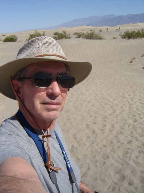
Today was a full and fulfilling day. I rose at 6 am, dressed, had breakfast and began to go over the information on Sequoia/Kings's Canyon. I picked the places I wanted to try to see since I only had the day. I left around 7:30 am for Sequoia National Park arriving around 8:30 and stopped at the Visitor Center and spoke with a Ranger about my plans. Some of the places I had selected were unavailable due to the remaing snow, unless you had snowshoes, which I didn't. The Range dis say that the road into King's Canyon was open and it was a great scenic drive. I headed on toward the Lodgepole Visitor Center, where I could catch a shuttle to see the General Sherman Sequoia. This is the largest tree on the planet as measured by volume. Not as tall as some redwoods but a much larger girth and main trunk, etc. I passed through the Giant Forest  and the General Sherman site on the way where the Sequoia's begin showing up. I arrived at the Lodgepole VC, got a stamp for my National Parks Passport and caught the shuttle to the General Sherman Tree and walked around there for a while. I met some nice folks from San Diego, Holland, London and China via Los Angeles on my trek around the tree site.

I Caught the shuttle back to the VC and headed on up toward King's Canyon as it was just past noon. It was a scenic drive through the forest and the winding mountain road, I stopped at one overlook where in the distance you could see the largest grove of redwoods on a mountain in the distance. Continuing on the the King's Canyon VC to see how far it was to drive into King's Canyon which was 36 miles and takes about an hour one way I got a stamp for my National Parks Passport and also purchased my Senior Lifetime Pass while I was there. I stopped up the road a couple of miles to the General Grant Tree site. This tree is the second largest tree. I met a couple from Fresno that were up for the day with their infant daughter. They took my picture in front of one of the Sequoia Trees.

I headed on toward King's Canyon and the drive drops over 3000 feet in the 36 miles.  The drive itself was great, going around the twisting mountain road at break neck speeds (OK so only 35-50 mph with 50 on the straight aways). I had the car in manual mode so I could down shift and up shift as necessary to control my speed around the curves. A lot of them were what my late wife called S.O.B. curves (slide over baby). It was a fun drive. That only paled by the scenery whizzing by. A good stretch of the road into the canyon parallels the King River as is flows out of the  canyon from the mountains. The stream was violent and furious as it washed over boulders in the river bed, creating rapids at various points. I did see two men standing on a big rock in one section fishing the river. I made it down the Cedar Grove which is the last stop before the end of the road and turned around and headed back up the canyon. The Visitor Center at Cedar Grove was still closed for the season and I couldn't get a stamp for my passport at that location.

On the way back I stopped at a couple of places I missed on the way down, Grizzly Falls and Boyden Cavern and took some pictures there. The drive back up the canyon was almost as exciting with the winding road, but it was up hill so you didn't have the downhill acceleration. I returned to Visalia, driving through a number of citrus groves and dairy farms on the way. Here is where I got the majority of bug splats for the day. I had supper at an Applebees and returned to the campsite around 7 pm. A full and eventful day.

Tomorrow I head over to San Francisco and will be there a week with my oldest daughter and her family.

See you down the road!

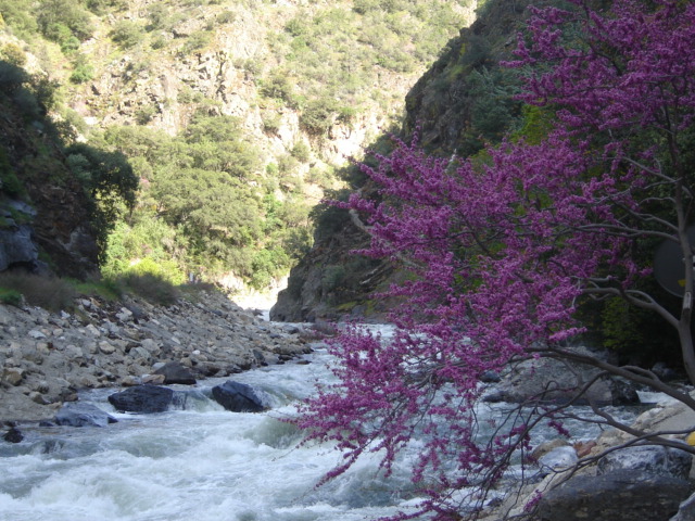
 Looking Upstream King River
 On the way to Sequoia
 Park Entrance
 Me and General Sherman
 Family from China enjoying the snow
 General Sherman from afar
 There's bears in them woods!
 Mountain with largest grove of redwoods
 General Grant
 No, I  did not fall off a log!!
 The back side of General Grant showing a burn scar
 Unknown man standing in front of General Grant
Me and General Grant

Friday, April 29, 2011

Day 8 - On to Sequoia, well almost

 Miles driven through Day 8
 Dust blowing across the road
 Dust obscurring the mountains on the road to Hwy 395
 Windmills on the road to Bakersfield
 Good bug splat
 Another good one
 KOA Campground campsite and clean car
Miles driven today
Today's bug count: Approximately 30 with some nice big ones on the way to Bakersfield

Today did not go exactly as planned as I'm sure many of them on this trip will be. I was awakened at 3 am by the arrival of a wind storm with gusts that must have been in the 40 mph range. I wondered if I and my tent were going to become part of the landscape of tumbleweeds blowing across the valley. The tent bobbed and weaved like a prize fighter. It bent and sage and did everything but break apart. After about two hours of that, around 5:15 am as it started getting daylight, I got up, dressed and fixed my coffee, inside the tent, and planned to start breaking camp early, knowing the wind was going to be a problem taking down the tent and folding the tarp. I sent my son, Kyle a text, wishing him a happy birthday (his 35th).  I started at 6 am and finished at 8:15am most of that time on the tent and tarp. At one point, I had my sleeping bag on the car between the open trunk and back windshield. A gust of wind came up closing the trunk and my sleeping bag began rolling across the campsite driven my the wind. I chased it down and put it in the trunk until I finished with the tent and tarp.

After everything was secured and packed away, I headed up to the Furnace Creek Resort and paid $5 for the use of the showers. It felt good to get all the dust and dirt off, but I also realized that I was tired already. I guess the combination of about 5 hours sleep and wrestling with the wind had zapped me. After I showered I went to the General Store for a snack and some drinks to take on the road. I left Death Valley around 9:30 at least two hours later than planned. I told Samantha where we were going and the poor girl seemed to be confused, because she took forever "Calculating". I finally headed on out toward Stove Pipe Wells while she figured it out. We had to go that way anyway.

As I drove toward Stove Pipe Wells and then on to Panamint Springs heading west out of Death Valley, I encounter a dust storm, part of the high winds that had blown in during the night. I was glad I picked Furnace Creek to camp, since the camp at Stove Pipe Wells was under the dust storm and would have made my ordeal even worse than it was. Praise the Lord for small blessings.

As I headed toward Panamint Springs I began to be concerned that I had enough fuel to make it out. I had forgotten that the exit west would be up hill and gas consumption would be higher. I made it to Panamint Springs and they had a Shell station, which had premium gas at the bargain price of $5.78 per gallon. I bought $25 and continued on. I had to go over two mountain roads to get out of Death Valley each going up to 4000-5000 feet elevation and then back down. Just a mile or two from Panamint Springs, Samantha wanted me to take a road I wasn't sure of so we continued on the road we were on. She became mildly annoyed at my decision, stating "Recalcutlating", but then she liked the route I was taking from there on.

I stopped in Bakersfield, CA for a quick lunch at Burger King and then continued on to Visalia, CA where I have a reservation at a KOA campground. I arrived around 3 pm and got a nice spot under a tree with an electrical hookup and set up camp, everything going up with no issues. Weather was mid 60s and light breeze. It was too late to go up to Sequoia National Park, about an hour away, so I went and got gas for the car ( a more reasonable? $4.35) and a car wash to wash all the dust off from the previous 2-3 days. After that I found a Marie Callender restaurant and had a nice supper. I am now back in my tent posting this entry with my little electric space heater keeping the chill of which is suppose to be in the 40s tonight. I even have WiFi at my tent so I can put these posts up!

Tomorrow morning I will head for Sequoia National Park and plan to spend the day there seeing all that I can see in one day. Sunday I will drive on in to San Francisco to see my daughter Kristen and her family and be there for my granddaughter's (Mary Judah) eighth birthday on Monday. So, later gator.

Day 7 - Touring Death Valley


Sunset At Zabriskie Point
 Mileage Leaving Death Valley
 Ouch!

 Pupfish
 King of the Hill
 Mosaic Canyon
 Pile of rocks somebody assembled
 I added my contribution
 The mosaic breccia

 Dante's View
 Artist's Drive
 Badwater Basin
Devil's Golf Course


Today’s Bug Count: 0 as far as I know.

Today was a full, tiring, and fulfilling day at Death Valley National Park.

I awoke this morning around 6 am as it started getting daylight. It was 82 degrees at 9 pm last night when I went to bed and 66 degrees when I got up this morning (nice!). I started out on top of the sheet and ended up under it with a light blanket. I fixed my coffee and ate my oatmeal bar and looked over the visitor’s guide to see what to possibly see today. I headed over the Visitor Center to talk with a Ranger about access to some of the sites in my low clearance auto. I got there a few minutes before they opened so I walked around Furnace Creek Ranch which is a resort lodge complete with palm tree lined golf course if you can believe that.

Went to the VC and talked with a Ranger and eliminated some sites due to the road conditions, etc. I stamped my National Parks Passport with the Death Valley stamp as proof of my visit.  I then headed out toward Stove Pipe Wells with a couple of stops on the way. I stopped at the Harmony Borax Works, then at the Salt Creek Trail which has the rare pupfish. Walked around the ½ mile loop and got some pictures of the pupfish at play. They were called pupfish because they “play like puppies”. I’m sure that’s a scientific term, etc. Their biological name is Cyprinodon Salinus, but pupfish is easier to remember.

I left Salt Creek and continued toward Stove Pipe wells and stopped at the Mesquite Flat Sand Dunes. I walked out on the dunes a ways until they all started to look the same and then headed back to the car. I continued on in to Stovepipe Wells, elevation 5 ft above sea level, and just past there to Mosaic Canyon. I had to navigate a gravel road for 2-1/2 miles but had no problem with clearance on the bottom of the car. I hiked up (and I do mean “up”) into the canyon for approximately 2 miles until it dead ended and turned back. After the first ½ mile there is the “mosaic” part with patterns of breccia, whatever that is. I’ll have to check that out when I get to an internet connection. The good news was the return trip was downhill and there was a breeze in my face which wasn’t there going up the canyon.

I headed back in to Stove Pipe Wells and had lunch at the “Saloon” dining on a turkey BLT and Death Valley Root Beer. After lunch I headed back to camp to get some more water to take on the trip south of Furnace Creek in the afternoon.

During my morning outing I met folks from Alberta Canada who have come from some of the parks where I am headed, Ohio, Colorado, Minnesota and Washington State.

The afternoon was spent driving 25 miles south to Dante’s View, at over 5,000 foot elevation. From there you can get a panoramic view of the southern end of Death Valley. The temperature up there was 73 compared to 91 at the campsite when I left. I drove back down to Furnace Creek and since I was getting a little low on gas and not wanting to chance it, I purchase $25 worth of premium that my care requires for $5.87 a gallon which is why I only bought $25 worth.

From there I headed back south on a different road toward Badwater and stopped at the Badwater Basin, which at 282 feet below sea level is the lowest spot in North America. On the way back from there I stopped at the Devil’s Golf Course and then at the Artist Drive which takes you through sections where the multi-color mountain surfaces are prominent. For some reason my pictures of Artist’s Drive did not come out. I must have had the camera setting messed up and all are over exposed and just “white”. I did get a few shots though. I returned to the campsite from Artist Drive had a quick meal and headed to Zabriskie Point to catch the sunset, which was fantastic as the pictures posted will attest. I am back at the campsite typing this up since I don’t have an internet connection and will post it tomorrow night along with yesterday’s offering. Currently the temperature inside the tent is 91 at 8 pm and there is a good breeze blowing in the campground. I am sitting outside the tent typing this where the breeze is stronger. It is fairly pleasant all things considered.

Tomorrow morning I will break camp and head to Visalia CA, about an hour or so from Sequoia National Park and be there Friday and Saturday. So I will see you down the road a bit.

Day 6 - Leaving Las Vegas and Arriving Death Valley

Mileage Upon Leaving Vegas

Yesterday and today’s Bug Count: Approximately 40

Today I trekked over from Vegas to Death Valley National Park. First of all, Samantha and I had a disagreement on how to get there. I had a route, I had plotted using AAA, taking me north from Vegas to Death Valley and she had one heading south. I said let’s go to my first stop 40 miles down the road to Indian Springs and she what you think. We did and she then liked my route on to the park. Once we got there, I was on my own to find the Visitor’s Center, which I did. Like I mentioned previously, Samantha gets a little confused in the parks for some reason. Oh, I forgot to mention the other day on my way to Vegas I passed a guy on a bicycle pulling a little trailer and I think it was a cross attached to it. On the trailer cover was the web address “bike4god.com”. I meant to check it out put haven’t as yet.

I was a little apprehensive of my time in Death Valley as the temperature forecast for today and tomorrow are the warmest days this week with highs in the 90s today and 100s tomorrow and I was sort of dreading setting up camp and having problems like I did at the Canyon but with 90 degree heat.

Driving into the park was quite surprising. I envisioned an arid, desolate landscape, etc., which it was, but I was unprepared for the mosaic of colors in the mountain ranges surrounding the park with their various hues of brown, red, tan, white, black and green. Reminded me of those sand art pieces where they layer different colors of sand into a pattern. Those had nothing on these mountains. They were amazing.

Checked in at the VC at Furnace Creek Ranch and asked about two campgrounds I was considering: Furnace Creek and Stove Pipe Wells. The Park Ranger said FC had trees and SPW didn’t. So I picked Furnace Creek which was a mile down the road from the Visitor Center and found a space with a shady area to set up the tent. Temperature was still in the 70s.  The tent went up with no issues like at the Grand Canyon and only had to set it up once.

Once I was all set up it was around 12:30 so I went back to the Furnace Creek Ranch and had lunch at the ‘Forty Niner” cafĂ©. I had their Bacon and Bleu hamburger which was pretty good. However, for Marvin’s and Ron’s benefit, just to let you know, Two Rows is better.

After lunch I went back to camp to see what to see this afternoon. When I got back after lunch I had to search for my clip-on sunglasses. I have lost them at each park so far. At the Gran Canyon I left them is the safety briefing area but they had them at the counter when I got back from my flight. Today I couldn’t find them on my way to lunch so when I got back I search through the car and the tent and could not find them to any avail. I decided to go on out to see Scotty’s Castle which is about 50 miles north. On my way out of the campground I remembered taking them off at the automated pay station so I could read the display and the polarization was making the screen all black. I had taken them off and put them on top of the station, and guess where I found them….right where I left them. So I am 2 for 2. Went on to Scotty’s Castle and got there about 30 minutes before the last tour started at 4pm. Ron that was a good suggestion of yours. It was definitely worth the trip and an interesting tour and the Park Ranger leading the tour did a good job of conveying the flavor of the individual’s involved in the building and living in the mansion. Definitely worth the trip

After Scotty’s Castel I went a few miles further north to Ubehebe Crater, which was created when a violent release of underground steam created a volcanic like explosion. I then headed back to the campsite. Before I left for Scotty’s Castle I told Samantha where the campsite was and she navigated me back there with no issues.
I met the couple at the campsite next to mine. Jim and Mary are from France, though Mary is originally from Michigan. The come to the states every couple of years for about 3 month’s vacation and have been to Death Valley many times, even in August, brave souls. The years they don’t come to the states they go to Morocco. They are leaving tomorrow headed toward Taos to meet her brother later this week.

For supper, since I had such a sumptuous meal at lunch, I dined on beef jerky, trail mix bar and Girl Scout cookies.

Tomorrow I plan to go toward Stove Pipe Wells and see some sites over there in the morning and back to the Furnace Creek area in the afternoon, hoping to catch the sunset a Zabriske point.

I think I will start putting the pictures at the end for the most part.

See you down the road!


Tuesday, April 26, 2011

Day 4 - Viva Las Vegas

Mileage upon leaving the Grand Canyon
 Pat Tillman Bypass Bridge

 Business on Historic Rte. 66 in Ash Fork Az
 Yesterday's Resaurant
 My Burger
 Inside Yesterday's
 Chloride Ghost Town


 Hoover Dam

Got a pretty good nights sleep but was awake at 6 am at the Yavapai lodge. Got ready and went to breakfast around 7 am and had the "All American" breakfast of scrambled eggs, hash browns, bacon, English muffin (that doesn't sound American does it?) and coffee at the Canyon Cafe at the lodge. Why do some places think if you dice potatoes and fry them you can call them hash browns. I think of has browns and shredded potatoes. After breakfast went to the gift shop for some souvonoirs for family. Checked out, loaded up the car and headed for the Mather Overlook for one last look on my way  out of the Grand Canyon.

Trekked over to Las Vegas with a stopover in Chloride, AZ for lunch at Yesterday's Restaurant. The building the restaurant is in dates back to 1860.  Chloride is a little desert town about 4 miles off the highway. I had Yesterday's World Famous burger. It was pretty good, but doesn't beat Two Rows Blue Cheese Bacon Burger, I'm just saying. Chloride is "famous" for it's mountain murals, painted by hippies in the 60s. Today I think you call that Graffiti! You need an all-wheel drive to get up to the murals or walk 1-1/2 miles up the mountain to see them. I decided to pass on the privilege. I did walk through Chloride's "ghost town" and took some pictures.

After lunch in Chloride I headed toward Las Vegas and stopped at the Hoover Dam and Pat Tillman bypass bridge. I walked over the bridge and got some good shots of the dam. Then over the the dam where I walked over Hoover Dam, then got in my car and drove over it and back since you can't exit on the Arizona side. Got some good shots of the bridge from the dam,

From there, I drove on in to Las Vegas, about 30 miles, to the Rio Suite Casino Hotel where I stay tonight before heading on to Death Valley. It is a nice place as most of these types of hotels in Vegas are and the price was inexpensive relatively. One thing that always bugs me about these places is that they charge for the internet connection, by the number of machines, so my Laptop and iPod count as 2. You stay in a Motel 6 and get free WiFi! But they charge because they can and you don't have other options unless you are on a 3G plan with a smart phone, etc.  I will probably venture on out to the "Casino" area and look for one of the many places to eat. I may even toss a quarter in a slot machine.

Samantha and I did fine on the trip to Vegas for the most part. She did get a little annoyed when I ventured off I-40 in Ash Fork to travel a section of Historic Route 66. She kept wanting me to get back on I-40, and after a couple of miles the Historic Route 66 section ended back at I-40 and she was happy again. I did notice she got a little confused in the Grand Canyon road system. I specifically told her where the campsite and the Yavapai lodge were so she could navigate us back there from some of our driving tours. Sometimes she would tell me to turn on such and such road in x miles and when I passed an intersection with some distance to go on her instructions she would start saying "Recalculating" as is I should have turned but didn't so I think the park roads confused her some. I guess she must not be much of an Outdoor type! She did get me to the hotel in Vegas with no problem though. ;-D

Tomorrow on the Death Valley National Park were the temps are in the 90s -100s the next two days. Since it is going be so hot I will probably take some driving tours around the park with some short hikes. I will drive north in the park to Scotty's Castle. Depending on when I get there tomorrow I may take in the Castle tomorrow afternoon..

See down the road.